A picture is worth a thousand words ...
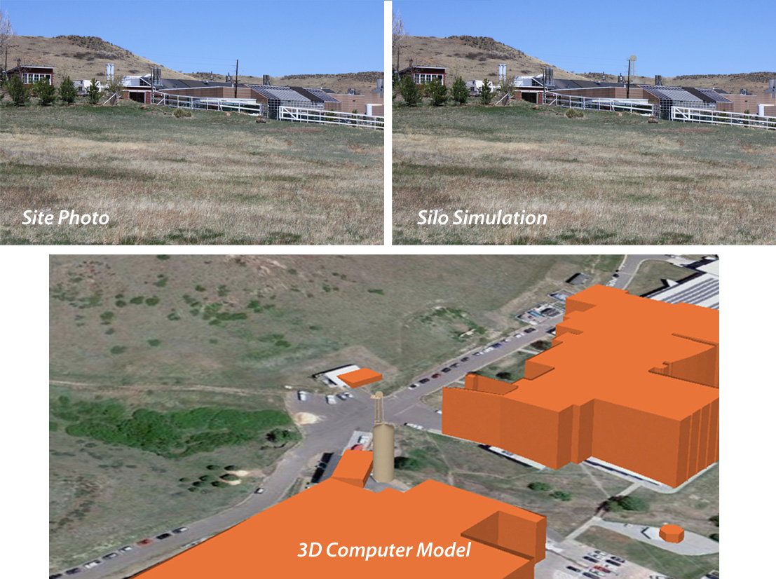
For public meetings, photo simulations can answer questions about visual impacts to the most laymen of crowds.
These images were generated for a proposed silo on the NREL campus near Golden, Colorado.
Friday, April 29. 2011
Yellowstone National Park map wins award
Periodically we like to showcase our clients' successes - successes that we feel we've made some humble contribution toward. Beartooth Publishing, from Bozeman, MT, has been producing a plethora of award-winning maps. They've published 2 maps that have won "Best of Category" for recreation and travel, and three additional maps winning "honorable mention" in Cartography and Geographic Information Society's annual map competitions. The latest (2010) winner was for Yellowstone National Park (cover shown below).
CTM has provided Beartooth Publishing the base data for these fabulous maps for many years, including hillshade imagery from our elevation server profiled in this post. Here's a hillshade example from their Yellowstone Map:
More on the elevation server coming soon...
CTM has provided Beartooth Publishing the base data for these fabulous maps for many years, including hillshade imagery from our elevation server profiled in this post. Here's a hillshade example from their Yellowstone Map:
More on the elevation server coming soon...
Friday, March 11. 2011
2D vs 3D maps
I have been working on a map of the Red Mountain Open Space in Larimer County (see below). It connects to an open space in Wyoming called the Big Hole Open Space. Though hill shading is a very effective tool to illustrate underling terrain, until we moved the map into 3D space, I completely missed the dramatic geologic "hole" that the area encompasses!
(Click on image for high res version)
Thursday, January 6. 2011
3D trail maps
The National Park Service did a study to evaluate(~6.8 megs) the effectiveness of 2D hiking maps compared to 3D hiking maps for communicating trail information. One finding was that in general, 3D maps enabled hikers to more accurately identify their position on the landscape compared to 2D maps. We've produced a both 2D & 3D maps for Larimer County's Natural Resource Recreation map, but the Horsetooth Mountain Park is one of my favorites.
Thursday, December 23. 2010
Making your property pop
Wednesday, October 27. 2010
Missoula, MT Trail map nearing completion
We've been working with Missoula, MT to create a parks and recreation map for the Town. After several rounds of edits, we're almost there. Though there are lots of fun features on the map, my favorite is their mountain backdrop peak finder. The aerial photo clearly shows off their "Letter Mountains", the M on Mount Sentinel (towering over the University of Montana) and the L located on Mount Jumbo. The "peace sign" is just out of view on Water Works Hill.
(Page 1 of 1, totaling 6 entries)